
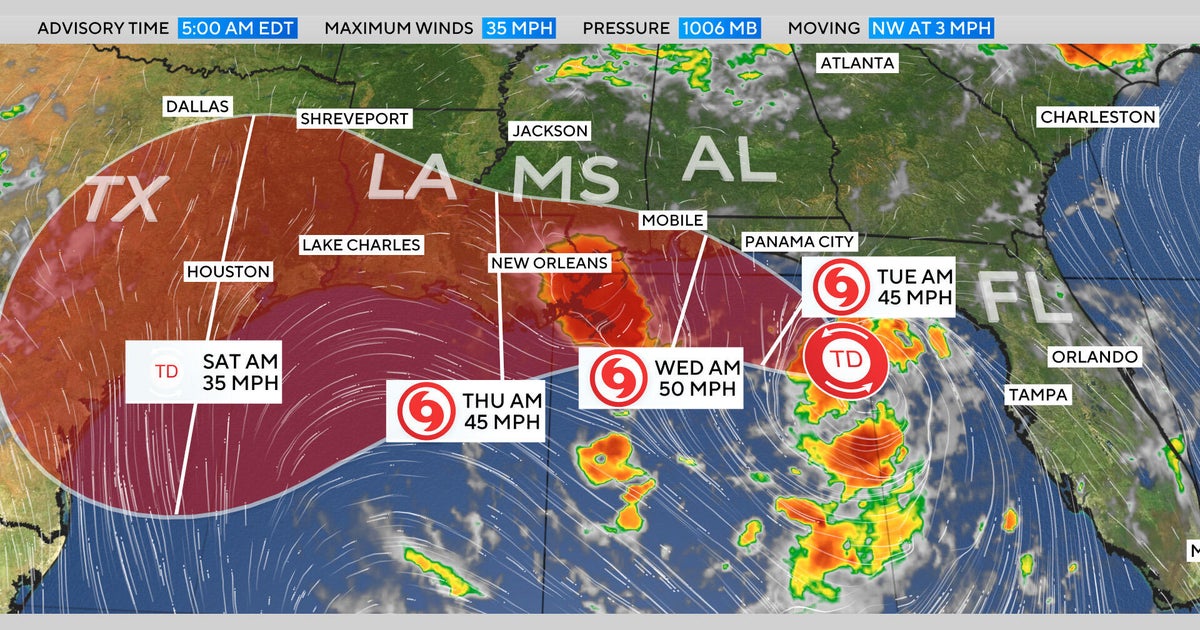
Tropical Storm Bertha made landfall in southeast Louisiana on Wednesday with winds of 45 mph.
Bertha formed Monday south of the Florida Panhandle and was bringing rain to large swaths of the northern Gulf Coast.
Weather forecasting models do not predict the storm will get stronger because of strong wind shear from the northeast, Phil Klotzbach, a senior researcher in the Department of Atmospheric Science at Colorado State University, said. Jamie Rhome, deputy director of the National Hurricane Center, said the wind shear is expected to push the bulk of the weather offshore and reduce rainfall totals. "We're not expecting a big flood event like we normally would with a slow-moving system," Rhome said. "As long as that continues to play out, Louisiana especially, could dodge some of the worst of the impacts."
A tropical storm watch has been in effect for New Orleans and the southern Gulf Coast of Louisiana since 4 p.m. Tuesday, and a coastal flood warning is in effect for the coastlines of Mississippi and Louisiana. A tropical storm warning was in place from Mobile, Alabama, to New Orleans.
Beaches were closed and sandbags were filled as the storm approached the Gulf Coast.
Panama City Beach recorded a 40 mph wind gust overnight into Wednesday. Pensacola Bay saw about 2 feet of storm surge on Wednesday morning, producing minor flooding in typically flood-prone areas. Similar minor coastal flooding was expected in southern Alabama and Mobile Bay on Wednesday morning and could occur again during high tide on Thursday morning.
The storm carried a high risk of deadly rip currents along the Gulf Coast from southwest Florida to Louisiana, with surf of 8 to 11 feet possible from the western Florida panhandle through southern Alabama.
Bertha began weakening and was expected to continue doing so as it moved slowly west along or near the Gulf Coast. Forecasts said as Bertha or its remnants reach west Texas by Thursday evening and Friday there would likely be very little left aside from light rain and breezy conditions.
Live updates said Bertha was targeting the Gulf Coast as a dangerous flood threat hit the Carolinas.
Forecasters said the 2026 hurricane season is expected to produce fewer storms than average because of a strong El Niño, but unusually warm sea surface temperatures in parts of the Atlantic could increase the likelihood of stronger storms. Jeff Berardelli, chief meteorologist and climate specialist at WFLA-TV in Tampa Bay, Fla., said, "The Gulf is high octane water for a storm right now because it's warmer than normal." Klotzbach said the percentage of more powerful category 4 and 5 hurricanes has increased over the last 30 years. Officials urged residents to prepare, make an evacuation plan, check insurance coverage and document valuables in case of damage.
NOAA satellite imagery taken at 10:30 a.m. EDT on Tuesday, July 21, showed Bertha moving along the Gulf of Mexico's northern coast. Forecasters said the storm was expected to track along the northern Gulf Coast for several days and could bring up to four feet of storm surge to some Gulf communities.
Sea surface temperatures are unusually high in parts of the Atlantic where hurricanes form because oceans have absorbed most of the extra heat trapped by pollution from burning oil, gas and coal, forecasters said.
Tornadoes swept across parts of the Midwest to the Northeast on Tuesday, leaving behind major damage.