
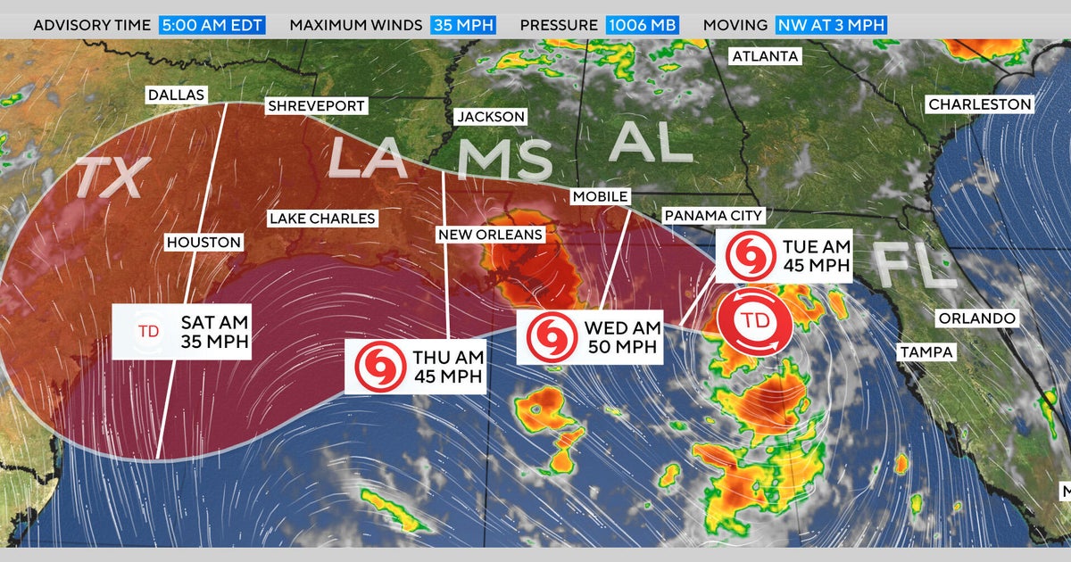
Tropical Storm Bertha formed Monday south of the Florida Panhandle, packing maximum sustained winds of 40 mph and threatening the northern Gulf Coast with heavy rain.
"A slow northwestward motion is expected through tonight, followed by a turn toward the west-northwest or west," the weather service said on Monday. "On the forecast track, the depression will move near or along the northern Gulf coast during the next several days."
A Tropical Storm Warning was in effect from the Alabama-Florida border to the Jefferson-Plaquemines Parish border in Louisiana. Tropical Storm Watches were in effect from the Bay-Gulf County line in Florida westward to the Florida-Alabama border, from west of the Jefferson-Plaquemines Parish border to Morgan City, Louisiana, and for the New Orleans metro area, Lake Pontchartrain and Lake Maurepas. A Storm Surge Watch was in effect for the Alabama-Florida border to the Mouth of the Mississippi River.
Forecasters warned of rainfall up to 8 inches in some areas and said rain was expected through the week along the Gulf Coast and in adjacent inland areas from western Florida to the Texas coast. Parts of Alabama, Mississippi and Louisiana will also be affected, and the rainfall could bring flash flooding. The system could also produce storm surge, raising waters up to 4 feet in some locations along the Gulf Coast.
A map of the system shows its expected track along the Gulf Coast, moving west from the Panhandle before reaching the New Orleans area and eventually eastern Texas later this week.
Bertha is the second named storm of the 2026 Atlantic hurricane season and comes weeks after Tropical Storm Arthur, which made landfall in June along the Gulf Coast of Texas.